Satellite Orbits
An orbit is classified by its altitude, which sets the period, delay, path loss and number of satellites needed for continuous global coverage.
| Orbit | Altitude | Period | Main uses |
|---|---|---|---|
| LEO | – | – | Mobile, imaging, broadband constellations |
| MEO | – | Several hours | Navigation (GPS/GNSS) |
| GEO | h | TV broadcast, FSS, VSAT | |
| HEO | Highly elliptical | Varies | High-latitude coverage |
Orbit classification by altitude.
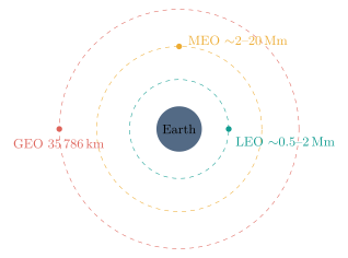
Concentric orbit altitudes: LEO, MEO and GEO around the Earth.
-
LEO: Low delay and low path loss; ideal for broadband constellations and mobile services, but the satellite moves fast, so many satellites and frequent inter-satellite handovers are needed.
-
MEO: Fewer satellites than LEO for global coverage with moderate delay and loss; the natural home of navigation systems, but still needs tracking or constellation planning.
-
GEO: A circular equatorial orbit whose period equals one sidereal day, so the satellite appears fixed. Fixed antennas need no tracking and three satellites cover almost the whole Earth except the poles, at the cost of high delay, high loss and poor polar coverage.
| Feature | LEO | MEO | GEO |
|---|---|---|---|
| Altitude | Low | Medium | km |
| Delay / path loss | Lowest | Medium | Highest |
| Coverage / satellite | Small | Medium | Very large |
| Satellites for global | Many | Moderate | |
| Tracking (fixed term.) | Needed | Needed | Not needed |
| Use | Broadband, imaging | GPS/GNSS | TV, VSAT, FSS |
LEO versus MEO versus GEO.